
Ever felt uneasy navigating on the water? Wanted to know your boat friend’s locations? Or looking for the best boat ramp or marina for the night?
The Wavve Boating app takes a new spin on traditional boating apps by providing all of this and more in one simple to use tool. Join a community of boaters and sailors building a network of marine knowledge for all to enjoy.
With Wavve Boating you get:
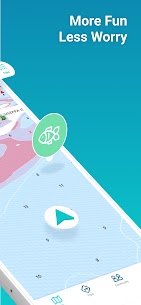
SIMPLE AND SEAMLESS MARINE NAVIGATION 😀
Forget those overcrowded and confusing maps and apps, with Wavve Boating GPS, it’s as easy as staying in the blue, and avoiding the red.
CUSTOMIZED MARINE CHARTS⛵🚤
Wavve Boating’s innovative approach allows boaters to view and change nautical charts based on their unique needs and preferences. You choose your draft and Wavve Boating redraws the marine chart data with your boat in mind. Marine charts are sourced from NOAA in the United States and CHS in Canada.
FLEETS OF FRIENDS🦈🐬🦑🐳
See who’s out on the water and where by adding friends to your fleet. Fleets make meeting up with friends on the water easy, and helping out other Wavvers even easier. Looking to boat under the radar? Easily hide your location at any time.
LOCAL KNOWLEDGE✔
Just like on the water, on Wavve Boating, we all help each other out. Our GPS map pinning functionality allows users to share their knowledge of lakes, rivers, oceans and any waterway. Our community of Wavvers vote on pins, making sure all pins are valid and valuable. Not willing to share a great find with other users? No problem. You have the option to keep the pins you add private.
TIDES
Track changes in water height in tidal regions, and along rivers and lakes with Wavve Boatings tides function. View a body of water in North America and the app will update to reflect the current water levels. View predicted water heights up to 18 hours in the future and track the next tidal variances.
WEATHER
Wavve Boating has a complete seven-day forecast across all of North America. Easily view the temperate, wind speed, and wave height as you move around the map.
Wavve Boating needs you! We’ve built the platform but it is boaters that will build our Wavver community. Share your knowledge, share your time, and save a prop or two in the process.
Current chart data includes coastal United States and Canada, The Great Lakes, The St. Lawrence River and portions of the Caribbean. You can view a map of our coverage at https://wavveboating.com/map/
GOODBYE CHART PLOTTER👏
Marine navigation is more than staring at a cluttered chart plotter. It’s about the fun of the journey. Forget buying marine charts piece by piece for your chart plotter. Wavve Boating has integrated all marine charts into one map for your boat GPS needs.
SUBSCRIPTION PRICING & TERMS📝
Wavve Boating is free to download. All customers are welcome to a free trial period. Should you choose to continue to use the Wavve Boating app after the free trial, we offer two auto-renewing subscription options, monthly ($4.99/month) or yearly ($24.99/year).
MORE INFORMATION➕
Want to learn more about Wavve Boating’s marine navigation aid? Still deciding if this is the right boat gps app for you to replace your chart plotter? Looking for an alternative to Navionics, Embark, Garmin Active Captain or other? Head to https://wavveboating.com to learn more.
TERMS OF SERVICE https://wavveboating.com/terms-of-service/
PRIVACY POLICY https://wavveboating.com/privacy-policy/


Multiple times while on the Waccamaw River it would not show channels and outlets that Google maps would. Multiple times I would have to use Google maps to get back to my original location. This app does not have full mapping capabilities. Also, and this is minor, I’ve tried connecting with other people multiple times and not one connection. Maybe they are not receiving the request but I do not find this very community friendly as advertised.. Canceling my subscription.
Any news on updating with a night version. It’s really the only thing missing. Otherwise great app but impossible to use at night with such a bright background. Please just invert the whites to black and charcoal with a darker blue for water. That would be great, thank you Why is there no night mode? Still learning the app but I don’t see a night mode or an actual way to navigate to a destination… Just shows where I am…… Still waiting on the night version
Very slow poor graphics, doesn’t show the fishing points has 0 usable information that you can’t get from free no subscription and no money apps. Used for a while and cancelled my subscription and uninstalled!!!! I can’t update a operation level that’s at peak also have used many other apps and worked fine!! This is not a good boat navigation app. OS Is not the problem Google maps works perfectly fine your graphics are slow and had issue with GPS location
Easy to use. I signed up for the free trial for 14 days and in those first 2 weeks I had no issues. Still nothing today to complain about either. My boating experiences are less cluttered with others now, and I’m grateful for the peace.