
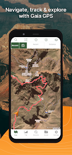
Find campgrounds, hike trails, and discover breathtaking offroading routes with Gaia GPS. Join the millions of people worldwide who use Gaia GPS maps to backpack, explore nature and navigate through scenic hiking and backpacking trails. Explore the outdoor world with Gaia GPS – the best backcountry navigator for hiking, camping and exploring the wilderness. Do more with offline maps, route planner, and distance tracker features that help you navigate the great outdoors.
Featured in countless publications like the New York Times, Washington Post, and GearJunkie, Gaia GPS is the outdoor app that provides the best offline maps and GPS navigation tools for your next adventure.
HIKING, BACKPACKING, TRAIL RUNNING
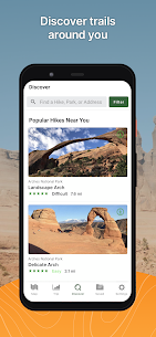
• Discover hiking trails and plan your routes with Gaia Topo, the world’s most powerful backcountry navigator.
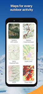
• Explore hundreds of professional topographic maps, including Nat Geo Trails Illustrated, USFS, and hi-res satellite imagery.
• Road trippers can enjoy plenty of routes, from national parks to backcountry trails.
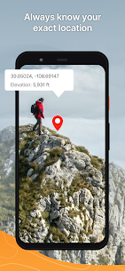
• Offline maps: Always know where you are, even when far from cell service.
• Navigate trails offroad and leave breadcrumbs on the map so you can always find your way back to base camp.
• Our app includes an altitude, elevation and distance tracker for each hike.
• Mark campgrounds and points of interest with GPS coordinates and drop photo waypoints.
ROUTE & TRIP PLANNER
• Road trip planner helps you stay prepared for your travel
• Route planner allows you to plan expeditions beforehand or create routes on the fly.
• Weather predictions help you stay on top of changing conditions.
• Stay safe in nature by monitoring wildfire activity in-app.
• Discover hiking trails and plan your routes with Gaia Topo, the world’s most powerful backcountry navigator.
CAMPING
• Use Gaia GPS as a camping app to discover campgrounds and reserve sites right from the map.
• Find camping sites far from the crowds with public and private land boundaries and USFS maps.
• Use GPS coordinates to mark your campsite, campgrounds and points of interest with GPS navigation tools.
OVERLANDING
• The premier outdoor activity app for planning, navigating, and recording 4×4 and overlanding adventures.
• Create new routes on the fly using your phone or tablet in the field thanks to snap-to-trail route building.
• Display your maps, routes, and waypoints on your dashboard with Android Auto integration to keep you on your trail.
BACKCOUNTRY SKIING
• Get avalanche forecast and terrain information with slope angle shading and topographic information.
• Record your ski tracks while you navigate through snowy trails & get SNOTEL data.
• Track your location with GPS navigation, so you can always find your way back.
PROFESSIONAL USE
• Gaia GPS is the preferred GPS navigation app for outdoor professionals.
• Quickly route to GPS coordinates and share maps, tracks, and waypoints with your team.
• Mark hiking trails, routes, campgrounds, & water sources.
• Share data with clients & fellow guides.
SUBSCRIPTION
• Free – limited maps, for online use only.
• Gaia GPS with O+ gives you expert-guided navigation, award-winning adventure films, premium content from Outside Online, access to Trailforks Pro, and more!
SIGNUP
• Gaia GPS is part of the Outside Inc, family. Create an Outside account to access the map.
TO MANAGE YOUR SUBSCRIPTION:
• TURN OFF auto-renewal: https://support.google.com/googleplay/answer/7018481
• Subscriptions automatically renew unless auto-renew is turned off at least 24 hours before the end of the current period. Your Google Play account will be charged for renewal within 24 hours of the end of the current period.
• Your Google Play Account will be charged at confirmation of purchase.
• Privacy Policy: http://www.gaiagps.com/gaiacloud-terms/
• Terms of use: http://www.gaiagps.com/terms_of_use


Very good, accurate tracking and has plenty of features even in the free app. I rarely do this, but I paid for the premium version because there were some tools that I needed that weren’t available in the free version. My only suggeation for the app would be the addition of a tool that shoots a line in the direction you’re looking. Would make it easier to certify that what I think I’m looking at on the map is what I think it is.
The documentation and screen shots are super out of date, to the point that the words and labels have changed and you cannot find them in the docs or screen shots. I tried to set the app to use my SD Card rather than internal storage and it crashes every time. Support told me to get a different SD Card and that was it, no asking for logs, no looking for errors, no investigation, just blame some 3rd party hardware & byby. Definitely should have tried it for more than a day before spending $$
Love it. Goodbye GPS. This is Google Earth meets GPS on Smartphone. Love the ability to see the very terrain we’re traveling. Recording, profiling features and data compilation are great. Mobile and desktop apps are pretty intuitive. Only reason this isn’t rated as perfect is the desktop app doesn’t have the same look and feel as the mobile (as usual), and the mobile responds better to the desktop for syncing than the alternative. Desktop app is sluggish.
I’ve been using gaia for years. It’s the best mapping system I’ve found for offroad and overland driving. The move to a monthly subscription by merging with a company I never heard of and don’t care about is a bad move. Not sure I’m going to renew my subscription when it’s up. I don’t do monthly subscriptions in general – they’re financially a bad idea. I much rather pay for period x and nothing renews automatically. For the app 5 stars, for the new premium model: 0 stars.
I love the range of maps Gaia offers and their offline map capability is reliable, more so than Alltrails, and that is most important to me. App has some issues though. One thing that is awful on this app is the route designer; difficult to use (on PC, would never try on a phone) and prone to weird glitches. There are also weird storage glitches where deleted items undelete themselves and items in a folder remove themselves from the folder. So the app could be better but I’m still a user.
I used Alltrails pro for years. Some annoying issues but very useful until years worth of maps disappeared from the phone’s SD card. Support said i should reinstall the app, download the maps again, but there is now no option to save to SD. Tried GAIA free and paid for it a week later. Better than Alltrails because 1. You can trace the outline of the map to download, not just a rectange. 2. You can choose map resolution before download. 3. Can save to a microsd card. Tried both apps, GAIA won.
If you’re into getting out into the mountains and the woods, this is your app. I use it for dirt biking and the MTB overlay is really nice for single track that isn’t mapped by usfs. The only thing I wish this had, like OnX does, is the ability to click on a trail and read a description about it, difficulty/rocks/slopes ect. Other than that this is a badass app. And they send you an email for 50% off, so a year subscription for premium is 20$! Can’t beat that!
This is the most useful navigation app I’ve found by far and I wish I could give it more stars. I use it almost every time I go hiking, camping, mountain biking, or even trip planning. I’ve found lots cool places on here as well. There’s so many map options, from latest snow depth/fall info, weather, lands, topography, trails… and then you can create and save trails as well. Cannot recommend enough
Best Map for Exploring I rely on this map for all my trail adventures. I’ve never had issues with tech disconnect …I love being able to plan an adventure ahead of time but have the choice of spontaneous travels… When on trails…I don’t use anything else… Google or paper maps… The only thing I don’t like is the arrow doesn’t follow along and you have to manually move the map as you travel. Can’t live without this app!!
I used to be a paid member. They make it purposely difficult to export multiple items at once. Their “solution” is to put the items into a folder and export the folder, which would be fine, except you have to open each item individually in order to move it. This is actually more steps than exporting one by one. I think it’s an attempt to keep you within their walled garden and I don’t appreciate that approach. I would rate it five stars otherwise.
Been using for 2 years. Bit of a learning curve but is the most informative mapping software for exploring the uncharted. The layers you can add are very useful, the satellite layers could be of better resolution. Anyone wanting to venture into national forests MVUM, Overland, Private Land, and 2016 USFS are my go-to layers. Long as GAIA stays affordable I’ll be a lifetime subscriber, hoping to score another 5 year subscription or longer when it comes time to renew.
The paid version is much better. Backroad map books is my favorite map. I do a lot of backroad/off road trails, and it shows roads, trails and even hiking trails that most maps don’t display, at least not all together. It does glitch from time to time, but I like being able to track where I’ve been so I can backtrack if I get off the main road or trail. I enjoy having all of my history in one spot! Hiking, off roading, and even city exploration in one convenient spot!
App works great! Wonderful features such as recording your route and placing way points with pictures. Awesome idea that it is now Android Auto capable. Lousy in practice. Have to have it open on your phone prior to connecting to the radio. Disappointing! I do enjoy all the overlays that it offers and that it has a map of the local publicly owned ORV park! I rated the app as a three due to the interface with Android Auto. Again having to open it up prior to connecting is tiresome.
*edit* thanks for the reply. Both of those features are still available. I was unaware on how to access them. 4 stars because the app used to be much more intuitive Used to love this app and recommend it to all of my co workers. I honestly don’t like it all that much anymore. What happened to features like: 1. Being able to have layers on fade 2. Seeing map download progress Overall the user-friendly app that I used to love has been garbage after the acquisition from outdoor magazine.
This app has great potential, but the software is very buggy: it locked up my note 9 phone & I had to do a hard reboot to get my phone up and running again. I think there are so many bells & whistles on this app, the user interface has gotten ahead of the spaghetti code software. Unfortunately. I had to uninstall the app (7/8/22).
Great detail, I use this app all the time for hiking, fishing, road trips, and any traveling. Whenever I get a new phone, it’s the first thing I install. The free version is great, I would like to purchase the premium but am able to get by with the basic version. If I was surveying or hunting or something more specific, I would definitely buy it.
When I first downloaded GAIA a few years ago it seemed to perform well and I was quite happy with it – so much so that I renewed my contract for 5 years (not cheap). However, they have made changes to the app that seem to cause more crashes and freeze-ups, and saved maps definitely load slower. Most frustrating of all is that I can no longer create area maps on my laptop; I can only do this function on my tiny phone screen. What idiot thought that change was a good idea? I’m about ready to delete the app and try a competitor’s product. GAIA used to be good, now it’s just frustrating!
PROS: Topo maps, wide range of territories, and the option to use it for free rather than pay money and THEN be disappointed. There are other GPS packages out there but not with topo that I found in a brief search. Cons: Scale is inaccurate (see other comments). This is a very serious flaw, and can actually be dangerous with the inexperienced. Comments: I will try to be brief – using the free app I took a series of screen grabs ( at the same scale) and made a composite in Adobe Photoshop. I missed some spots. I then go back into the app, and take screen grabs of the missing regions and import those. The scale bar is exactly the same, but the terrain is 35-50% different in size. As I adjusted the layers to fit with the existing panels, the terrain would fit but the scale bar was much larger. This casts a lot of doubt on the scaling at any level. I am planning a trip to the Arctic Circle, something my climbing partner and I have never done and while I would have my compass, map, and probably an old black and white garmin for safety purposes, I thought I would give this a go. It’s a nice app, but the scale bar to me is a very serious thing for meticulous planning (or if you call in for a rescue, you could be miles away from where you think you are). What I am saying is the map zooms in, or out, but the scale bar is the same. This is not good. I work a LOT with other software packages that use scale bars, and it matters. While not GPS, they are high end commercial applications, but a quick confidence check in ImageJ (or photoshop if you like to work hard) the scaling is off. Or am I imagining this?
I have been using the app for years. There are a lot of times recently where the GPS marker won’t show up on the map, which defeats the purpose of paying for a GPS app in the first place. I also have been unable to load downloaded maps to full resolution, which never used to be an issue. The map updates are nice, but critical functionality is becoming unreliable.
If I depended on this app for survival I’d be dead. The app crashes constantly. Nearly every time it goes in the background it crashes. It even locks up my whole device. This happens on both devices I have it installed on. It locks up nearly every single time I do anything. Save a waypoint? Crash. Hit “Record” crash. Just sitting there doing nothing. Crash. The interface is not well laid out. When in portrait mode roughly 50% of the map is hidden by the buttons. The “Record” button and “Take picture” button are on both sides of the UI in portrait mode. Why are these buttons on the primary interface and why have them there twice? And there is a whole band of white space to left of the Search button. Why take up so much real estate on the interface and make it blank? On that note, the Distance and Ascent are also just taking up space on the UI unless the trip is being recorded. Why take up space on the interface when it’s not being used? It is incredibly poor UI design. I want to see the map, not a bunch of unless buttons & white space. When saving an area, I can’t resize the red square until I cancel out and try again. Still haven’t figured out how to save any layers with a map that give any useful detail. The first time I used the “save map along route” option, I only got the roads I was traveling on. In a area that doesn’t have cell reception and need to make a side trip – too bad I am now lost.
I love this app! I have gotten lost quite a few times while trail running and have found my way back Everytime thanks to this. Location pinpoint is spot on with perfect directional pointer. I have only found one issue so far. The Tuscarora trail in PA is a little messed up on the map. When out there today I noticed that the all shows the trail about a mile off of where it should cross route 74. However, this trail in real life is very well marked so it’s not a big deal. Just wanted to point out!
Great app. I’m a paying customer. I switched from OnX because their offline map downloading was too tedious to cover larger areas at different zoom levels. Gaia is simple and easy, select your download area and let it go. Also great customer service. Had an issue where the app quit working right on my phone and they helped me fix it in under 48 hours. While that might not help if you are in the backcountry. This is the first problem I have had in 2 years and the fix was easy.
I had been using a professional quality GPS program on my phone for years. They upped the annual subscription to $250 so it was time for a change. I downloaded GAIA and sent for a hike. It is super easy to use. I wish more apps had such an intuitive interface. I like it so well I went to their website and signed up for a subscription so that I could download maps as I live in a rural area with lousy cell service. I highly recommend it. Update 05.21.2019. There is one glitch in this program that I have found. The map stops updating on the screen on a random basis. If I close and reopen Gaia it updates the map. It appears that it is still collected location data even though the screen appears to be locked up.
4 stars: great functionality, some core issues which make the app difficult to use with Android. I used the app on iPhone for about a year while bikepacking through South America; the ability to save offline satellite imagery, along with everything else, made it better than the rest. No complaints there. This review is for Android; for the past few years I have used Android (currently 8.0) and have experienced a few difficulties with Gaia. I still use the app sometimes for planning, because the same functionality is still there: easy storage access, an intuitive UI, functional auto-routing, offline storage of a mind-blowing amount of map layers, and so much more. Yet, despite all of this, for day-to-day navigation, both abroad and back home, I have switched to another app. Why? 1) Gaia is slow. It’s laggy. It takes a few seconds, sometimes two, sometimes ten, to turn on location and “unfreeze” when switching from other apps, which is a deal-breaker when I’m trail running and need a quick reference of which way to turn at the upcoming junction. 2) Offline map storage is just… weird. To be fair, I haven’t tried to save maps using Gaia in about 9 months, because my last experience was so horrendous. Offline maps took up an immense amount of storage — over 10 times the amount they should have — which filled up my phone. Gaia Support’s solution was to transfer everything to a memory card, which was unsuccessful, perhaps because of the sheer amount of data that was being transferred and no feedback from the app if a transfer was underway. It also didn’t really fix the problem; 2 GB of new maps take much longer than 200MB to download on shared wi-fi in a Kathmandu hostel, whether to a memory card or internal storage. Ultimately I deleted everything, freeing up all my storage, and switched to another app, which fixed my problem immediately. One small thing: the Gaia topo rendering is great (imperial units, yay!), but sometimes lacks topography (blank backdrop). Seems to be related to steep areas, clustered contour lines. Overall, decent app, room for improvement. UPDATE 10/8 Gaia support contacted me 2 days after my original review; they’re working on it. Thanks for the responsiveness!
The interface is an abomination. Created by a designer who only uses Apple products, then not updated in years. I tried to view a trail by tapping on the trail, then tapping “Guide Me” (the other option was “Driving Directions”) and it popped up a red line from my current location to the trailhead, as if to say, “well, first you go to the trail…” So apparently there’s no actual trail data. But that’s fine, I created a Route on the website…and that doesn’t show up in the app, while signed into the same account. So I need to create the route in the actual app? Uninstall.
This has been extremely useful for route finding for canyoneering. Of course you can use it for any outdoor navigation but I’ve found it useful because I can download files of the exact routes from canyoneering websites. The topos are detailed and you can add more maps than I know what to do with. I’ve also never had any issues with gps working accurately unless I was in very deep canyons. About my only problem with the app is the price. But to be honest, the value is there so it’s not too bad.
I bought this app so I can save routes for future off-road trips. Unfortunately the stock map is what it uses for trail markings and only has a handful of trails. When using the low resolution satellite maps, you can see there is very clearly a trail that’s even labeled but I cant actually place a route on it. Unless I’m missing something, it certainly wont work for me. Of course they already have my money just so I could find out it was useless for me. I sure wish it it had a short demo period.
Had the app for 12 years, now coming back to it on my new phone and it is requiring a subscription just for even offline map downloading. Sucks to be there from the beginning and now having to pay $40 a year for something as simple as this. Might have to find something else. The use of the app was always great and the map layers are great. Just not worth the yearly expenses for this. Too bad. Update: After review I was contacted by the team and was able to come to a equitable resolution.
Great maps with plenty of layers for anything you can think of. The data management needs some work though, its not possible to bulk edit anything, and you cant do any sorting into folders unless on desktop which is also fairly slow and cumbersome. It’s very limited in that regard. Locus maps is a great example of the kind of data tools needed.
I really wanted to like this app and unfortunately I’ve already paid for a subscription. For the most part the app is pretty nice with the premium features but there’s one big problem! Planning routes is very clunky and unreliable. The auto router tends to do what it wants. The other problem and this is a big deal for me is that it crashes when you try to save a route.
A lot to like but fundamentally broken. Seemingly random spikes in location tracking make it unusable. This is a known problem but none of the recommended solutions work. I’ve tried most of the competing apps and this is the only one with that tracking issue. I opened a ticket and waited two weeks but no reply from them so no choice but to un-install. It’s a shame because aside from the tracking problem it was my favorite out of all the ones that I tried.
Excellent app for creating routes. I use it primarily for planning motorcycle rides. User friendly interface and easy to use across devices. Also has an option to track your route to find places again when exploring. Easy to download or share routes as well. If you are looking for the best route to a location, stick with Google maps. If you want to create, track, or share your own route, this is a great app to use.
Decent app. Stats bar takes up too much real estate, though. Yes, you can turn it off, but then you lose the ability to record a track. There’s also a button to fully expand the map which is nice. But I seem to always need to undo that in order to recenter the map. Perhaps more buttons need to be made transparent rather that being on status bars. One other request. You need to display arrows on the tracks so we know which direction to take on a loop hike
I have used Gaia for about two years now. Overall a wonderful app. Good way to find trail heads as it shows all the roads too. I do lots of bushwhacking and is spot on for location. Location is usually right where the trail is on the app. The one area that could be improved to make it perfect is on the map, the mileage between trail junctions, as I have to use other apps for that.
The user interface is not the most intuitive. I also wish it was possible to export multiple items at once. Is there a way to edit saved tracks? If I delete a waypoint on my iPhone, does it disappear from my android phone? If I save a section of maps to one device, will it start downloading on all my devices? Can I control that? Why can’t I change which statistics are displayed on each screen? Can Gaia calculate rate of ascent? I only want to download maps at zoom level 8; I don’t need the rest.
I’ve been using this for about 3 years now for all my off road adventures on bike and snowmobile. I’ve saved multiple off line due to lack of service, and never had any issues with it. Even using the eyeride display it still works seamlessly. The maps are incredibly accurate, easy to read, and reliable. Users control everything, so you know when a trail is still good or impossible. Users can make your own, and or follow somebody else’s route. This has become my absolute go to.
Doesn’t need a subscription fee in order to make a new trail route which is great. The map itself could use some updating though, I have found multiple inacuracies in my local national park area such as trails that don’t meet, trails in the wrong spot, or places where there should be a trail but it isn’t shown on the map.
No voice navigation and automatic map rotation was removed and replaced with manual rotation. Why? The lack of these features make it useless for off-road motorcycle riding. In a ORV, you need a second person to read the map and give you directions. Very inconvenient. Edit: “Tapping the locate icon a second time enables Course Mode. Rotating your phone in course mode rotates the map, mirroring what you see on the ground.” Not intuitive, but upped it to 3 stars for that.
Not sure what the point to this app is. First the compass doesn’t work at all, no matter wich way I face the reading is the same. Secondly the points of intrest are extremely limited it only shows a small portion of the campsites in my region. If I had to take a guess it shows less than 20%. Thirdly I thought maybe just maybe if I upgrade to basic paid membership i would get improved listings however when I click on upgrade it shows me that it is “unavailable”. Say what!? Unavailable? Really?
Worked for a while, then became wildly inaccurate on my Android phone. (E.g. 5 mi. hike records as 30 mi., with speeds approaching 100 mph, and track looks like I’ve done multiple parallel trips both on and off the trail.) Followed all Troubleshooting Tips, and contacted Customer Service. They are stumped too. I dont trust it, and currently I can’t recommend it.