
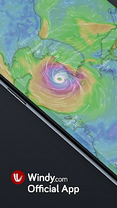
Windy.com is an extraordinary tool for weather forecast visualization. It’s fast, intuitive, detailed and most accurate weather app trusted by professional pilots, paragliders, skydivers, kiters, surfers, boaters, fishermen, storm chasers and weather geeks, and even by governments, army staffs and rescue teams.
Whether you are tracking a tropical storm or potential severe weather, planning a trip, pursuing your favourite outdoor sport, or you just need to know if it will rain this weekend, Windy provides you with the most up-to-date weather forecast around.
The uniqueness of Windy lies in the fact that it brings you better quality information than the other weather apps’ pro-features, while our product is absolutely free and even without ads.
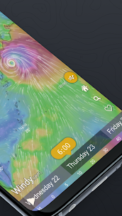
Powerful, smooth and fluid presentation makes weather forecasting a real pleasure!
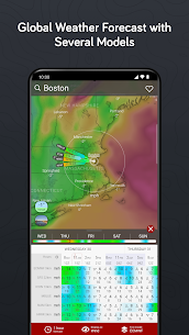
All forecast models at once
Windy brings you all the world’s leading weather forecasting models: global ECMWF, GFS and ICON plus local NEMS, AROME, ICON EU and ICON-D2 (for Europe). Furthermore NAM and HRRR (for the USA) and ACCESS (for Australia).
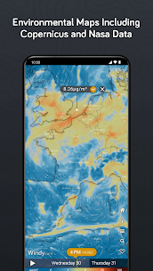
51 weather maps
From wind, rain, temperature and pressure to swell or CAPE index, with Windy you will have all convenient weather maps just at your fingertips.
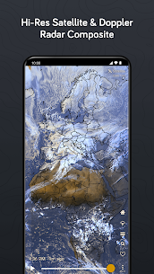
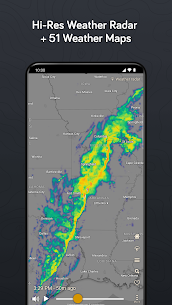
Satellite & Doppler radar
Global satellite composite is created from NOAA, EUMETSAT, and Himawari. The image frequency is 5-15 minutes based on area. Doppler radar covers large parts of Europe, America, Asia, and Australia.
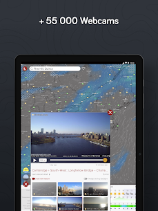
Point of interests
Windy lets you display observed wind and temperature, forecasted weather, airports around the World, collection of 55 000 weather webcams and 1500+ paragliding spots right on the map.
Fully customizable
Add your favourite weather maps to quick menu, customize colour palette on any layer, access advanced options in the settings. All that makes Windy the weather geek’s tool of choice.
Features and data sources
✅ All leading weather forecast models: ECMWF, GFS by NOAA, ICON and more
✅ Several local weather models NEMS, ICON EU and ICON-D2, AROME, NAM, HRRR, ACCESS
✅ High-Res satellite composite
✅ Forecast model comparison
✅ 51 global weather maps
✅ Weather radar for many world locations
✅ 16 altitude levels from the surface to 13.5km/FL450
✅ Metric or imperial units
✅ Detailed weather forecast for any location (temperature, rain and snow accumulation, wind speed, wind gusts and wind direction)
✅ Detailed Airgram and Meteogram
✅ Meteogram: temperature and dew point, wind speed and wind gusts, pressure, precipitation, altitude cloud cover
✅ Altitude and Time zone info, Sunrise and Sunset time for any location
✅ Customizable list of Favorite spots (with the option to create mobile or e-mail alerts for upcoming weather conditions)
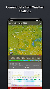
✅ Nearby weather stations (Real-time observed weather – Reported wind direction, wind speed and temperature)
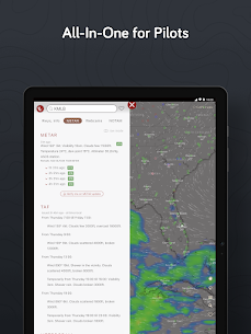
✅ 50k+ Airports searchable by ICAO and IATA, including runway info, decoded & raw METARs, TAF and NOTAMs
✅ 1500+ Paragliding spots
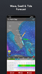
✅ Detailed wind and wave forecast for any kiting or surfing spot
✅ 55K Weather webcams
✅ Tide forecast
✅ Topographic maps by Mapy.cz and Satellite imagery by Here Maps
✅ English + 40 other world languages
✅ Now with Wear OS application
…and many more
Get in touch
💬
Join us at community.windy.com to discuss weather related topics or suggest new features.
Follow us on social media
• Facebook: facebook.com/windyforecast
• Twitter: twitter.com/windycom
• YouTube: youtube.com
• Instagram: instagram.com/windy_forecast


I love windy and use the mobile app and the desktop/web app extensively. One area for improvement that i would appreciate is the ability to turn lighting sounds off by default as well as different options or sources for the doppler. The doppler radar with the “smooth look” looks nice but does not always accurately show whats actually happening. I have found accuweather to be more percise in this manner. Thank you very much.
Si far this seems to be fairly accurate application. I like all the different information available. Once you go through the menu you can really see a lot of things which is excellent. One issues us that when I use it in a mountain location the temperature in winter is way off from a real temperatures night or day, i mean easily by more than 10 degrees. Now i understand better after the reply from developer of the app.
This app is good & also a useful tool for tracking different storms in different parts of the world, but there’s one thing that makes it not 5 stars. This is the color representing the wind speed. The color scale needs to be more broad. For example. The purple. I see what looks like a storm & is purple, but is it the low purple wind speeds? OR The storm level high purple wind speeds? One of the purple colors in the scale needs to be replaced. You can’t have 1 color represent 2 different things!
I love everything about this app! You can get multiple weather reports for anywhere in the world, check volcano activity through SO2 levels, plan for rough surf, high tide and even track wildfires. There us so much in this app, it is great and easy to see the data rather than just looking at raw data. I’ve stopped using the weather channel. This even has traffic cams if you need to check the roads.
this is one of the greatest weather apps you can get if you’re a weather nerd. literally everything you could possibly want, no extraneous ads that make it hard to see, and it’s extremely intuitive. the only minor change I might make is swapping the label from “Rain” to “precipitation”, because it threw me off when I wanted to see the model predicted snowfall.
Lot of access on a little screen. Lucky for I have used Premium Website access for years. Layouts between the two are similar, I knew what I was looking for. Smartphone app is compact requiring more navigation. Data transfers quickly. Screen images are clear with smooth animation. Premium is ad free, so far, moving between devices. Very satisfied with developer innovation. Adding weather warnings access was a good move. Very responsive.
I would be willing to pay the annual subscription if you could alter the radar to be zoomed in automatically, where you leave off the last time. The radar is great and I love the app, but in the widget it’s too zoomed out and when you click on it, you still have to zoom in every time. It seems like a simple fix yet it never happens.
Decent layout, several models to select. Unable to clear search history, this should be easy to fix. Also CAP alerts rarely ever show for USA, stuck using another app for alerts and warnings. This includes warnings, watches and advisories. Still only getting a partial amount of NWS weather alerts. App needs to clarify if only warnings will populate on map, or not. Far too many advisories, watches are not on map.
Invaluable resource. I used to subscribe to the premium content just because I wanted to support them. The premium content really isn’t that premium. However during covid we were unable to get back to our boat due to travel restrictions. I received an email saying they had renewed my annual subscription the day before. I immediately contacted them to request a refund since we would not be on the boat that year and they told me tough. They refused a refund despite covid times so I no longer do.
Choice from different weather prediction models gives a more accurate forecast. Many optional details can be added or subtracted from the UI. Lots of localised weather stations feeding data. Webcams are shown on UI menu . Big Bummer is the live webcams in the wildland areas are no longer available but were very helpful in seeing current conditions with real time visual.
I really wanted to use this app, and came really close to purchasing the premium subscription. The large weather maps and animated wind patterns, plus all the other interesting layers that are available are nothing short of amazing. But the tiny fonts and tiny controls are just too hard to use. I mean I can manage, but it’s uncomfortable, Even worse, there is no option to adjust this. The developers are essentially leaving out everyone without perfect eyesight.
One of the best weather forecast apps. Many layers you can keep watch on, and several models you can use. Offers the ECMWF for free, which is extremely rare. But there are more features behind a premium subscription so… Also, if you go on the desktop version, you can create custom colors for layers which will transfer to your phone, if you are logged into the same account. Really cool! I recommend this app.
The most user-friendly weather map system in existence. I use this app all the time, but especially love it for the ability to see weather patterns throughout a range of regions. The map allows me to see which areas around me have the best potential for the wind. However, it is not at all limited to wind readings. All other weather features are useful for anyone. My only complaint is that the forecasted wind gusts tend to be missleadingly high. Otherwise the accuracy is good.
I really like the features of this app with regard to switching between various weather elements on the same map. If I had one issue, it’s the home view when the app starts. it’s always zoomed way out, so I have to zoom in to my city each time I start it up to see relevant local info. I’ve looked around for a way to save a desired default start up view, but just haven’t been successful in finding it, if it exists. I’m probably missing something obvious. 😁
Wow. Simple layout with a LOT of detail at your fingertips should you choose to access it (see the sandwich menu). Select the layers you want — or the weather model, even. I like that it gives projected rainfall AMOUNTS, rather than percentage of likelihood. Much more useful. Quite reliable, too. For all it’s features, if it were unreliable, I would find another app. But it’s become my go-to.
This app is perfect in so many ways. When I first started using it, I was a couple miles offshore in a sailboat and needed to know what the wind was going to be doing. Easy peasy – it shows that right away and it’s probably the best app on the market for that. A couple weeks later I’m concerned with the wave height – lo and behold, Windy does that too. Is there fog nearby? The forecast map doesn’t show much, but they have video feeds at certain locations and I can tap into those. The list goes on and on. It’s the best broad-view weather app, in my opinion.
Excellent weather app. Loads of information available in a smooth and aesthetically-pleasing way. The GUI is relatively intuitive, though there are some parts that remain unexplained. A full built-in guide for this app would be very useful so that I could understand everything that it is showing me. Lastly, the real-time lightning feature is waaaaay cool– I was freaking out about how cool it is when I first discovered it!
This app is so, so powerful. It’s like downloading a superpower. Looking at the wind visualizations over the Atlantic ocean makes me drool in awe at a complexity of wind patterns I had never considered. As an amateur drone pilot, it’s way more than I need, but still incredibly useful. I’m sure it would be even more useful if the interface was explained somehow, with lablels or a sort of tutorial view. All the same, it’s been a fun puzzle to explore.
I was really happy with this app when I first got it. I feel like now that they’re pushing the subscription model, it’s lacking. For example – it can pull weather from 4-5 different sources, some more accurate than others. However, it never remembers the choice and defaults to the same one. Just today there is a 5 degree difference in the forecasted high between this and accuweather. I tried to choose the option that was closer, but nothing changed.– note to dev- I paid for the old Windy app.
This app has a good feature set; it could be made better by allowing the user to set a default weather model and the ability to zoom in on the airgram (the text is so small). Other than that, it’s really useful and relatively accurate. *Update* Please, please, please add the ability to set the desired default weather model! Also, an on-map wind altitude slider like the website would be a much more fluid user experience.
This app is incredible, but it has two flaws that I know of. 1) There is no way to have it show your location upon startup. You must click the menu and precisely touch the “find my location” option, which can be tricky when driving a bouncy semi truck. It would be greatly useful to have an option for it to startup with current location on the map. 2) When using the map to check wind and gust speeds, your view is blocked by some unnecessary window, and you have to try again. Please fix this!
The interface can be a bit daunting/confusing, but the data is all there, more than you could ask for. 3 other QOL features I would like is 1. Some sort of visual feedback when clicking the “use my location” button on the main screen. 2. I would like to be able to get the 1hr forecast enabled by default on my premium account. 3. I would like to pan around the map without moving the pin.
So pretty. The animated arrows are true art – not too in your face, communicating a lot of information, and pleasant to look at. The forecasting models used don’t do that great a job of figuring out the wind velocity close to shore, generally way too low as if it is assumed the lower wind speed on land is predominant even a kilometer or two off shore. Poor assumption in littoral waters. Room to improve those estimation algorithms. In general, finding it entertaining, educational, and useful.
I really like the live radar widget that you can add to your home screen. Gives you a instant look at your area. Although when I’m not connected to WiFi it doesn’t load. Maybe that’s a problem on my end in my settings somewhere, idk. I haven’t really looked into it. Seems to be as accurate as other apps I have on my phone. I haven’t really dug into all the features yet but for a quick overview of the day and the week I like it. It’s become my go to weather app currently.
Basically tells you everything about what’s going on short of geological details. It’s fun to just explore the intricacies of the atmosphere and ocean, while still being able to observe and ingest useful information. Easy and endlessly customizable interface with more layers than you can shake a stick at. Go ahead and try: I just stood there dumbfounded, holding the stick like an idiot. I couldn’t shake it at all. This is a beautiful app.
Great visualization but you missed a target demographic of users…Truck drivers. If you could add a US highway system and better city center locations overlay that would be really helpful. Otherwise it’s a fantastic app. EDIT: I’ll give you that 5th star when you add visible highways to the map. It’s not that difficult… they’re already there and they don’t move.
Best weather app there is. May look complex at first sight, but so does anything that covers as much information accurately. I do mean accurately. I drive a high profile vehicle and it is important for me to know when and where to get off the road. This app has saved my hide numerous times. Compared to other wind and weather apps Windy is at the forefront of what they should be. Informative, accurate, and reliable.
I don’t know what I am doing wrong, I created an account, changed all the settings to be mph, in, ft, mi, etc. Every time I save my settings and go back, everything is back to metric measurements. I uninstalled and reinstalled twice, went into settings multiple times, cannot get it to change over. I love Windy in the browser but this doesn’t work. I have a hard time changing weather forecasting model too. Definitely some bugs.
Si far this seems to be fairly accurate application. I like all the different information available. Once you go through the menu you can really see a lot of things which is excellent. One issues us that when I use it in a mountain location the temperature in winter is way off from a real temperatures night or day, i mean easily by more than 10 degrees. Now i understand better after the reply from developer of the app.
This app is good & also a useful tool for tracking different storms in different parts of the world, but there’s one thing that makes it not 5 stars. This is the color representing the wind speed. The color scale needs to be more broad. For example. The purple. I see what looks like a storm & is purple, but is it the low purple wind speeds? OR The storm level high purple wind speeds? One of the purple colors in the scale needs to be replaced. You can’t have 1 color represent 2 different things!
Gives new meaning to “watching the weather”. Good source for all kinds of weather information. The app gets better all the time. For me, a drop in barometric pressure can trigger a migraine. With Windy. com, I can spot those triggers (literally) and prevent migraines. It also tracks the storms that hit the area in summer and winter. Thanks, Windy!
Many unique and attractive layers and maps, but one really large shortcoming: the ability to have more than one layer active at any one time. I subscribed for over a year hoping that they would change course, but despite many requests by others via their forums, I don’t think they are inclined to add the feature. For me, having radar, storm track, warnings and frontal boundary layers active is a big deal, so I will be switching to an app that offers those capabilities.
Finally, an app with a working radar widget on Android 9 Pie! My long search seems to finally be at an end. The features and capabilities are great and the map detail is as well. However, one complaint is that even after logging in some of my settings do not save. Sound is always re-enabled after exiting and reopening the app even when I mute it. I’d also like the option to set a default view & layer set (e.g. I want to open it up and go right to radar) rather than have it always start on the wind view. But it’s a great app and I look forward to seeing it improve!
One of the worst app UIs I’ve ever seen. Always requires you to scroll (very sluggish) down to your location, sometimes it even starts you far away from it. And many times the back button will exit the app instead of the sub-screen, requiring you to go through that delicate zoom-in process. And on top of that, the UI is very not intuitive. It’s sad since it has the best data and is a great way to visualize every interesting aspect of the weather at macro and micro scales.
Good for being free but defaults to wind map which I don’t find useful. To get local weather and radar takes a few more clicks and time than I’d like. The webapp version is more useful to me since I can set it as weather radar by default and the interface seems to work better – there were random bugs with changing the settings and scaling on the app that don’t seem to be present on the website version. The weather functionality is pretty good but it’s not the focus of this app it seems.
I love windy and use the mobile app and the desktop/web app extensively. One area for improvement that i would appreciate is the ability to turn lighting sounds off by default as well as different options or sources for the doppler. The doppler radar with the “smooth look” looks nice but does not always accurately show whats actually happening. I have found accuweather to be more percise in this manner. Thank you very much.
Would be a good app, but UI is very glitchy. None of the views and selections are remembered, starting with the map zoom level- it just returns to the default zoom every time I switch back to the app, by simply switching between open apps. Forecast graph settings, such as Basic/Wind, forecast models, etc are also reset every single time and not saved as per the last selections. The touch interface is very buggy- location selection is way off half the time, does not select the location pressed.
As a farmer, a weather app is much needed. For years I was using the Storm app. It gave me alerts when rain was about to start, nearby lightning strikes, and weather alerts. The radar was always on point too. The colors were defined. If there was any color overhead, 99% of the time there was some sort of precipitation occurring. Windy doesn’t send notifications, and I can’t trust the radar colors. Half the time a system will look bigger on Windy than another app. If changes were made, I’d use.
This app was very helpful with understanding in real time where hurricane Dorian was and its projected path. It also was helpful to know what the wind speeds where on the different rings of the hurricane. A helpful change might be to show the scale of colors for wind speeds higher than 70 mph. The scale is a little confusing with the higher speeds.
Love the interface and display quality. The frame blending is also very nice. If you like interpreting the info, this app makes it fairly easy. Great selection of outdoor sports selection, too. Did not like how it presumed an early southerly trajectory for Hurricane Florence, but fortunately it ended up on that trajectory.
Love the advanced weather model data! Especially the winds at multiple Altitudes. I can even see the Jetstream above 400 mb level. It goes All the way up to the 250 mb level, almost 40,000 feet. Also, I can see model data from the EURO, & GFS models in one easy to use app. Plus the fire data is unparalleled. Nice radar, precipitation, clouds, & air quality. It’s almost my main weather app. I just would like graphical hourly data for local regions. The local data in Windy, is not as detailed.
One of my favorite apps, by far my favorite weather app. Between the many options for layers on the map and the multiple options for forecast models, there is enough info available to really get a good idea of what’s going on in the atmosphere. Extremely user friendly and overall very well executed. I recommend this app to everyone.
Spontaneously changed from MPH to BFT. Is there a gesture I accidentally did or something? Either way, that shouldn’t happen. Edit: very much so. I wouldn’t have complained about it if it wasn’t set. Maybe there’s a tiny button that I didn’t notice on who main screen or something? This app isn’t very intuitive even for tech savvy people but I understand you have to present that plethora of options and information somehow.
It’s kind of scummy to lock something as simple as being able to pick a default layer behind a paywall. When I open the app I actually watch it change from whatever layer I had open before to the wind layer. Someone spent time to program that. Premium features should be things that take time and talent to develop, not a way to just get rid of contrived roadblocks. That said I might subscribe if there was a monthly option. But I’m not commit to $20 for what’s really not even that much more.
smooth satellite motion, and the time progress slider bar, allow me to see the hidden images amongs the clouds. Don’t believe me? remember, clouds, by nature, are not symmetrical. Use all the filters (blue, vis, IR), to see these images, and use the time progress slider bar to roll time back and forth. you will see things animate. Right now 1/25/23 is classic war plane propeller engines, submarines, war ships and the front of airplanes (usually look like the front of a Boeing or Airbus) Enjoy
(/Still/ having widget issues with “current location.” I’m leaving a review while I’m re-downloading the app. Tedious, but it seems to solve the issue for a while.) Great app. Definitely download it and figure it out. It’s a great app for data nerds. I’d ask for a UX redesign though, I feel we’re centimeters away from the finish line. And I’ve had it turn my friends off of the service, but they are happy to use the web app on a computer.
Lots of good data that I’d normally have to go to multiple websites to view,which is nice. What isn’t nice is the lack of forecasting and hourly breakdowns unless you pay. A typical phone home screen will give you an hourly forecast for free so I don’t see why someone would pay for it. Otherwise,the app is impressively quick to load considering how detailed the map is even though it takes a bit of fiddling to learn what all the buttons do and which data you want to see.
I started using this app because I was visiting an area with strong and changing winds. It works great for that, and then I also noticed the app has a great interface for forecasts. It packs a lot of info in simple displays, and shows changes in a continuous chart, unlike the more common format of hourly or daily chunks. Windy is my new go-to weather app!
this is an interesting tool and i like it for what I assume is it’s primary purpose, looking at big weather patterns in a beautiful interface. sadly, current, local reporting seems kind of tacked on. even with current data available from various nearby sources, it appears to display the forecast for the current weather rather than the actual data. you can get at that actual data, but when the default home display is constantly off from every other data source it’s not a good general app.
Great app overall! I really appreciate the depth of information it provides as well as the multiple weather sources. There are multiple different ways you are able to visualize the information which helps to see the past, present, and potential future trends. Plus it is ad free (as of September 18, 2019…please don’t change that!) which is always wonderful.