
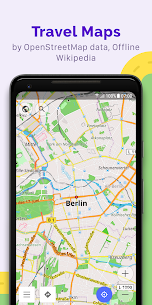
OsmAnd is an offline world map application based on OpenStreetMap (OSM), which allows you to navigate taking into account the preferred roads and vehicle dimensions. Plan routes based on inclines and record GPX tracks without an internet connection.
OsmAnd is an open source app. We do not collect user data and you decide what data the app will have access to.
Main features:
Map view
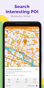
• Choice of places to be displayed on the map: attractions, food, health and more;
• Search for places by address, name, coordinates, or category;
• Map styles for the convenience of different activities: touring view, nautical map, winter and ski, topographic, desert, off-road, and others;
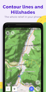
• Shading relief and plug-in contour lines;
• Ability to overlay different sources of maps on top of each other;
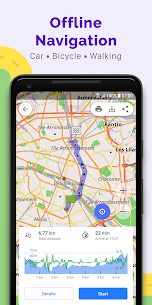
GPS Navigation
• Plotting a route to a place without an Internet connection;
• Customizable navigation profiles for different vehicles: cars, motorcycles, bicycles, 4×4, pedestrians, boats, public transport, and more;
• Change the constructed route, taking into account the exclusion of certain roads or road surfaces;
• Customizable information widgets about the route: distance, speed, remaining travel time, distance to turn, and more;
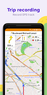
Route Planning and Recording
• Plotting a route point by point using one or multiple navigation profiles;
• Route recording using GPX tracks;
• Manage GPX tracks: displaying your own or imported GPX tracks on the map, navigating through them;
• Visual data about the route – descents/ascents, distances;
• Ability to share GPX track in OpenStreetMap;
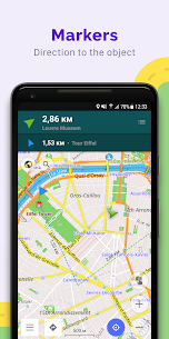
Creation of points with different functionality
• Favourites;
• Markers;
• Audio/video notes;
OpenStreetMap
• Making edits to OSM;
• Updating maps with a frequency of up to one hour;
Additional features
• Android Auto support;
• Compass and radius ruler;
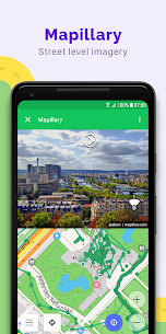
• Mapillary interface;
• Night theme;
• Wikipedia;
• Large community of users around the world, documentation, and support;
Paid features:
Maps+ (in-app or subscription)
• Unlimited map downloads;
• Topo data (Contour lines and Terrain);
• Nautical depths;
• Offline Wikipedia;
• Offline Wikivoyage – Travel guides;
OsmAnd Pro (subscription)
• All Maps+ features;
• OsmAnd Cloud (backup and restore);
• Pro features;
• Hourly map updates.


It’s a great app…very accurate; but, lately, I find that I can’t get the map(s) to center properly; that is, they won’t stay centered to the middle of the screen (they lock to the bottom of the screen). Every fix I’ve tried doesn’t work. I would ask the developers to fix this in the source code, since uninstalling/reinstalling the app suggests a far larger problem within the app itself. Also, include a folder for storing offline maps, as some phones seem to have issues in this respect. Thanks!
Can be a frustrating to learn but worth the effort. If you have become accustomed to one of the big name commercial applications the number of options in OsmAnd can be overwhelming to set up/use. There will be times when you will be surprised at things that “pop up” or possibly disappear for no apparent reason but spend a day or two playing with it and it will all make sense. The learning process is why I did not give it 5 stars but, once mastered, it is worth 5 stars.
The existence of Open Street Map is wonderful, and this app is a very useful interface for OSM. I’ve been using it for some years. I like to use it to track hikes for milage and route, and to see what points of interest (POI) are around, and I’ve used to navigate while driving when I didn’t have mobile signal (e.g. in central PA and in Canada)…. There are many options, which can be difficult to navigate at first, but you’ll come to appreciate all the options.
Could use a bit of an update, the app takes a lot of battery especially when on the road. The UI could maybe use a rework too. But overall, the mapping works well for me though, shows almost all of the street names, and the location tracking is pretty good! This definitely is a great alternative to Google Maps though, especially for offline use.
Powerful free app with turn by turn guidance. The interface isn’t the most intuitive, but it’s very customizable. I wish you could easily “skip next waypoint”, but it seems you must go into your route and manually delete it. That is a bit of a pain if you’re navigating a complicated route and don’t come near enough to a waypoint to clear it automatically.
Much better than Google Maps for navigating by foot or by bike. User submissions makes all the little paths available, and makes sure that they are actually usable (or they wouldn’t have been submitted). Offline maps work really well, too, even in back country. I always make sure to download the region if I plan to go hiking. Only downside compared to Google Maps is the user interface for navigation, which could still use some work. Wonderful project!
You are limited to download 7 maps (in my case states) which I didn’t initially realise but is fine. While learning how to use the app I downloaded 7 states that I had taken a motorcycle trip through and it worked great. Then I deleted the states thinking that I could just replace those with new states. I was wrong. Not only no new states but, I can’t get the old ones either! The app is now completely useless unless you want to look at a blank outline of the continent! Total waste of time!
I really wanted to like this app. Like many others, I’ve been wanting to ditch Google wherever I can. I’m fine with the ugly UI and slightly disorganized features (which there at a ton of). The issue for me was that I couldn’t search by an address. I had to find the nearest cross street. If I could just type an address into the search bar and have it show up, I would hands down use this instead of Google maps. As of now, I’ll probably keep using Google until I find a better option.
Mediocre at first. Then I actually really like it now. I have submitted thousands of map edits in my area and am building it out to help with providing an alternative to big tech maps. Things I learned. If editing, addresses on buildings only get updated on monthly map updates. Which typically happen at the end of the month for update cutoff and roll out for download within 2 weeks of end of the month. I look forward to continuing my contributions and putting places on the map!
Hands down the best navigation app, *unless* you want traffic data (Google Maps is still king for that). Offline navigation, hiking & biking, skiing & snowboarding, recording tracks … and very, very configurable. For those complaining that the UI is too complex, well, there are a ton of features squeezed in this app, so, yes. I’d rather have a complex, but fully featured app rather than a easy, but dumbed-down app, as seems to be fashionable these days.
I really do love this app for off-grid navigation. It’s really really really powerful and not at all intuitive. Many of the functions are buried in menus and submenus, so something as s simple as uploading and following a GPX file is really tedious. I also wish it could work off of routes developed on Basecamp or something. That said, it has all the features you could want, and is my main nav for more complex trips. For simple nav, I just use Google Maps and download the maps.
It’s good, but lacks refinement with address searching. Doesn’t find exact street number, often doesn’t find streets due to mis-spellings in the map itself. Directions often go down non-connected streets or those that no longer exist for years. Can find some things by name, like schools, but is only about 75% accurate. Doesn’t account for traffic. Features are good here, though. I like the overlay option and the offline maps, and setting parking spots, but interface takes getting used to.
I was looking to turn my old phone into an offline GPS nav system. This app looked like it would be great for that. I download the map for my state and tried to type in a few addresses to which I wanted to navigate. It could only seem to find landmarks or named buildings, but not a simple street address. A navigation system that doesn’t have that feature is worthless to me. I removed the app.
Gives directions very poorly, with very little notice. Doesn’t say what street you’re turning on most of the time, and is constantly “recalculating” even when you follow the directions. Worst navigation app I’ve tried yet. EDIT: I tried it on several routes in Albuquerque, NM, and it never gave more than 2/10 mile notice about a turn, except on the freeway, where it gave 4/10 mile. The only street names it gave for turns were the major intersections. Residential, business, or even minor through-streets were rarely, if ever, named. Thinking about it, I suppose it’s possible that this was why the app kept saying “recalculating,” since I had no way to verify if I was turning on the correct street, or a street too early, since the only notice I got was 2/10 mi or “turn right.”
A flexible, powerful navigation app. My only real complaint—and it’s becoming a deal breaker—is the inability to gracefully handle skipped waypoints when I’m following a route and there’s a detour or I’ve missed a turn. I’ll keep using the app, but if I find an app that handles missed/skipped waypoints better, that’ll be the one that ultimately wins me over. I’m tired of the app relentlessly instructing me to make a u-turn and then another u-turn just to stay “on route.”
I read that with this app you could customize what info you wanted shown on your map. I even read it would show road surface quality which would be awesome out here in the country. There was no setup tutorial and it wasn’t user friendly at all. Maybe the review I read was way wrong, but even still I couldn’t get directions, it said my starting point was too far from the nearest road. I live litterally 100 feet from a county road. The map only showed state highways and interstates. Useless.
This app has so much raw power and potential, I’ve actually purchased the paid version on a different account before. Unfortunately it’s extremely hard to use as a drop in replacement for driving since it does not have any obvious way to specify a numbered address, it only seems willing to direct me to the street or road itself, and asking it a specific number on that road might not work. Edit: I’m seeing that this may be a problem with open map’s data. Other than that and some optimizing, gr8!
An amazing navigational app and location search tool! I love that I can see opening and closing times for places that have them updated on OSM. The interface is a bit daunting and takes a bit of practice/research to understand, but the online documentation for OSMAnd is wonderful as well, and after that learning curve it’s an incredibly powerful tool. I use it any time I travel, and also to double check any updates I make to OSM!
Have been using this app (paid) for years now for bicycling / exploring remote areas without cell services. Works great with a cheap android phone on my handlebars, more capabilities and larger, better display than dedicated bike products like Garmin / Wahoo. Pro: offline maps of the entire planet, excellent detail, highly configurable / customizable, so many features, large worldwide user base, it just plain works. Con: lots of menu’s / options / configuration settings can be a bit confusing. But that’s pretty minor. I recommend it to everyone who travels in areas of poor cell coverage. Has saved me from wandering “lost” many times when cell signal unexpectedly dropped.
I’m disappointed in OsmAnd coming from iPhone 6S. I have a newer Android with much better CPU, newer GPU, way more RAM, yet panning around the map is not smooth. I can’t even rotate the map precisely like I can on iPhone. On both versions this isn’t my app of choice for looking up addresses. However, offline maps and offline navigation do work excellently especially for cycling, so this is still a keeper for me. Also fun to explore around in sometimes.
Almost impossible to plan a route with multiple destinations unless you want to backtrack over 50% or more. This was never a good app for such route mapping, now it is just an excercise in utter frustration and essentially useless. If you need to plan more than a start point and end point, look elsewhereqa1. There is also a HUGE number of roads listed as paved that are actually dirt roads. Edit – it now only navigates from beginning to end point of existing loop routes. Ugh. Ended subscription.
Thank God, a way better alternative than Google Maps and all the other bad navigational apps out there. I live in an area with horrible cell and gps service, but it seems like this app is magic. I highly recommend downloading all your maps. Their offline mode works 100% without any cell data needed, but you still need an internet connection to download the maps in the first place.
Though it takes a while to learn how it all works, OsmAnd is a powerful navigation tool. Once you optimize each preset, like one for hiking and one for driving, it’s easy to switch dozens of settings easily. So your driving preset can have a simple road map that orients the map to your direction of travel, while the hiking preset can have topo and satellite overlays (simultaneously!) and bearing readout without map rotation. And all of this can be set up for offline use, which is wonderful
An essential app. Never an issue with maps becoming expired & deleted out from under your feet like ‘That Map App’ we all are first given However, I would like to make a feature request, as there’s a few things missing that ought to be important When you have recorded and or imported tracks as much as I have, you will find that there’s no way to decide if you should delete a track while in the GPX menu. There needs to be a way to ‘show track on map’, in order to decide if it’s important It would also be nice if the track log menu could organize tracks based on wherever the on map locator has been left at, either the current location, or when you move the locator to a intended destination The track recordings are named by date & time, but after a year goes by, I couldn’t recall which day I was at any particular location. So when it comes time to go back to a favorite campsite, or whatever it is, I have no practical way to choose the correct recording. This is why organizing the tracks by map position would be very useful For GPX users, look at: android/data/net.osmand/files/tracks Custom tracks can go here. Recorded tracks are in the ‘rec’ folder
OsmAnd app has functioned brilliantly for exploration during trail running, cycling, and motorcycling. The off-grid functionality is very useful, as many of the areas I explore do NOT have reliable cell coverage. I also especially appreciate the ability to easily use a GPX track, which I have created on my PC, then sent to my phone. OsmAnd is the easiest to use of the several similar app I have tried. An easy 5 out of 5 stars.
I love that this app is not creepy, and doesn’t steal/sell your data, and the UI seems easy to use (looks recently updated). BUT I can’t give higher than 1 star, because it completely failed to find any addresses at all. I understand it’s based on an open source map, but really, navigating to an address is the only thing a driving nav app needs to do well.
It shows promise, but at this time, I find its usefulness a bit limited. If I put an address into a calendar entry, for example, and then tap it and open with this app, it often cannot find it. It is more useful when browsing the map to find something manually, if you have a good idea about where it is you’re looking for. I recognize that part of this has to do with the particular map source I have selected, and that can only get better over time.
I’ve bought and tried all the big name map applications and not one brings enough for me to change so far. I will always look for one thats better. I almost changed to Rever last year just because of the trail playback feature but that just didn’t overcome deficiencies in other areas. 3000 miles Canada to Mexico on dirtbike trails with zero issues. Alpine loop, perfect. GPX planning, a caveman can do it. Used it daily for 5 years on my job and is my go to for off grid (satellite only) navigation
I want to like this app but I could not even find my own address or the address of a friend when I searched for it as a preliminary test. It basically requires you to know the closest intersecting road: but what if you dont know it ? When I looked up my address a little further (took me a while to even find it in the list of possible results), it was listed in the wrong county. So nice features and it does have a lot of potential, if only the maps would be accurate.. that’s a no go for me.
OsmAnd is a must when I’m mountain biking. It shows trails you won’t find on Google and you can add your own custom markers to the map. The compass feature is a life saver and GPX logging basically leaves a breadcrumb trail on your map. The tracks auto-save so you can look at them again later. I can’t believe this incredible app is free!
I have used it for about a week now. In my car and on my motorcycle. The interface takes some time to get used too. There is a lot of information displayed in a very good, common sense way, but still a lot of info. That said, the navigation screen should have an option to display the map in a tilted almost 3D view, like Google Map does it. And the icon for the car or MC should be in the lower part of the screen, not the center. Other than that, awesome app.
In places with up-to-date OpenStreetMap data, this app performs wonderfully. Navigation offers good advice about lanes, stop signs, etc. In places with poor OSM data, the app performs in accordance with the quality of data available. Wrong turns, awkward lane suggestions, etc. This, unfortunately, includes most small towns I’m aware of. I’m an OSM mapper, so I consider each odd thing I see in OsmAnd to be a fun opportunity to improve things. But this may frustrate others.
These are open source maps, so not every business is listed, but you can save and organize locations. When I find a place that I want to remember, but isn’t listed in the app, I mark it as a favorite. I love the fact that it offers navigation for walking, biking, and public transport. Great for English language Android users in Beijing.
Severe handicap. 7 maps DOWNLOADS or updates. Not a 7 map collection, but consumable downloads. Deleted a few maps, hoping to ‘free up some slots’. Wrong, none of that. Very handy, but now of limited use. I should just pony up, because it’s a great app, but every time I’ve finally bought the “better product” I’ve been severely disappointed.
I tried this, and then the paid version. In my limited experience before I missed the refund window, this app is frustratingly difficult to use. It might be good for local navigation with downloaded maps, but forget x-country. Ex: in Atlanta, looking for home in SC. It couldn’t find my address! POIs are incomplete, and can only be listed alphabetically, not by distance. There’s far better, and easier, apps than this. UPDATE: Tried it again after more than a year, and it’s still pretty worthless.
Worst map ever. Put in an address to test it and it tried to route me the opposite direction! As i continued to drive in the right direction (east instead of west like it was trying to take me) it kept trying to route me to the next exit to turn around. If i didn’t actually know this address I would have gone the wrong way into heavier traffic conditions. Can’t trust it.
MapQuest and Google Maps are absolute garbage compared to this. This app does not require internet connection, and you can download maps for offline usage. It doesn’t harvest your data or location whatsoever, and is totally open-source! This is the ONLY Navigation App that I would EVER recommend to someone. It’s just that damn good!
One of my favorite apps. I use it all the time for hiking and biking, HOWEVER!! I have purchased the Live version and it has been horrible since. The GPS is all over the place, the GPX lines are 5-6 times the thickness all of the sudden. I haven’t really gained much by paying more, but it sure feels like i lost a lot. Very disappointed.
I too was hoping to use this app to de-Google, but there are just so many gotchas in the UI that I can’t justify the time to learn it. I tried several times to navigate a long bike ride, but couldn’t find a straightforward way to enter an address & navigate there (much less enter a business name), and I’m a developer! I’m baffled that an app for mapping places & routes would require going into sub-menus in order to enter a destination. Until OsmAnd gets serious about UX design I’m out.
Please don’t follow driving directions. It gives very good map with details but can’t be worse for directions. This will end your journey with car dividing into river. Unbelievably it directs drive thru houses, jungle and river even when driving mode is car. Also not free at all. Limited to 6 download including updates which happens in a few days. Still most of shopping plaza are shown empty blocks with everything missing. It good for all non-driving purposes like walking hiking etc.