
View gpx, kml, kmz, loc files, but get a lot more features. See why we are one of the best rated offline vector maps app. GPX Viewer is the ultimate GPS locator, GPS tracks viewer, editor, analyzer and simple navigation tool for your trips and outdoor activities.
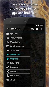
GPX, KML, KMZ AND LOC
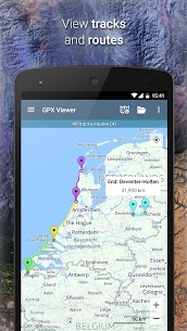
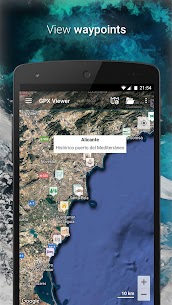
• view tracks, routes and waypoints from gpx, kml, kmz and loc files
• edit tracks, routes and waypoints metadata
• file browser which opens multiple files and has support for favorite files and history
• compress gpx files into gpz and kml files into kmz (zip archives)
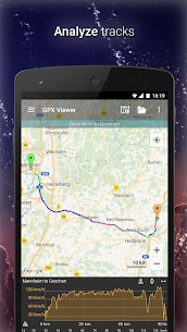
DETAILED TRIP STATS
• analyze information and statistics for tracks and routes
• view graphs (charts) like elevation profile and speed profile for tracks and routes
• view graphs of other track data like cadence, heart rate, power and air temperature
• analyze information for waypoints and adjust their icons
• change track and route color
• colorize track and route line by elevation, speed, cadence, heart rate or air temperature
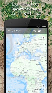
ONLINE MAPS
• online maps such as Google Maps, Mapbox, HERE, Thunderforest and some others based on OpenStreetMap data, preview: https://go.vecturagames.com/online (Mapbox, HERE and Thunderforest online maps needs to be purchased)
• OpenWeatherMap weather layers and overlays (needs to be purchased)
• add your custom online TMS or WMS maps
SIMPLE NAVIGATION TOOL
• show current GPS position on a map
• follow GPS position continuously by adjusting map position
• rotate map according to device orientation sensor or according to movement direction data from GPS
• with follow GPS position and rotate map features, GPX Viewer can be used as a simple navigation tool
• notification when GPS position is near waypoint with adjustable distance
TRACKBOOK INTEGRATION
• synchronize tracks and waypoints created on Trackbook – https://trackbook.online
———
GPX Viewer is highly customizable. You can set everything according to your needs!
If you want feature rich gpx viewer that is also tool with simple navigation, online maps, GPS locator, GPS tracks viewer, trip stats viewer and has other useful features, GPX Viewer is the best app for that!


Edit 2 : Based on your last feedback…. Updating my rating…..Hope no location data stored at your level of access. edit : In short location data must be stored locally in phone and not on your server and also should not be shared/published with any third party for marketing/profit making etc. Moreover sensitive data must not be shared incase of merger etc as other information can easily tracked based on location and time activity. Above are few t&c mentioned in your policies…
I use it for dual sport motorcycling. It syncs with TRACKBOOK ONLINE and makes building custom routes super easy. Then it tracks the GPS and follows the route. Makes navigating dirt roads super simple and easy to plan overnight longer camping trips that cover some distance.
Originally Installed this app on Nokia 6.1 running Android 10 which has excellent battery life. Noticed the battery running down very quickly (about 1% every 5 minutes with nothing else running!). Stopped the app from Settings, battery still running down fast.. Restarted phone – battery still running down fast. Uninstalled this app, Restarted phone – battery now back to normal consumption – 1% in 1 hour! I have another solution so will not be trying this app again. UPDATE: I did try it again on the recommendation of a friend. There has been an update in the 4 months since I last used it, and it no longer drains my battery as I said above. Furthermore I now find it quite useful alongside other apps when walking. Upgrading from 1 to 4 stars. UPDATE May 2022 After contacting Support, I was told that “Follow GPS” mode does actually use more battery. I’m not certain how I had that set ORIGINALLY but I’ve chosen to disable this function. That most certainly saves battery.
Good app for basic uses. At least with my data I only don’t get all my maps info. I get description, and name. It is also too “smart” that it overrides my spoofed GPS data which in my case is a high accuracy external antenna. Basic uses are great however! It can be a bit tricky to get onto.
This is a fantastic app for viewing tracks and routes and displaying full information. Really impressed. Lots of features and Help with all of them. Invaluable once you get used to its way of working, fast rendition of maps.
This app failed my use case immediately. I tried to open a GPX that isn’t really big (480 kB) but it has a lot of small tracks (1200 tracks with 8000 trackpoints in total) and the app choked on that file. It hanged and I had to kill it.
i love how i can see all of my flights on one map. i use ppgps but its hard see tracks one at a time. the first time i fired up this app it blew me away. it was exactly what i was looking for. i still need to explore the app more but so far I LOVE IT
First time using the App. Found a great walk in the lakes. Downloaded it straight to the app. The area has zero phone coverage but the app worked brilliantly. When I went off track the app quickly shown me my error and guided me back. I’m actually amazed how good this app is. Wish I knew about it previously. Can’t recommend it enough. Especially of you’re like me and no good with conventional maps.
It’s amazing. Gives an accurate location of your position and easy to use so far.
So there is a paid version that also has inapp purchases? And ads? Is there a paid version that is just paid with everything and no third party trackers?
The distance given for the walk we did was totally wrong. Gpx said 7km, it was a ctually 14km. A major difference.
Can’t figure this app out. I tried to open a downloaded gpx file but needed to give this app access to all files on my phone, and agree that “it can read and modify files without notification”. No way am I doing that. As I backed out, the app asked for review. So this is your review as requested
Really like this. Surprising that it is not more well known. Does exactly what I wanted. Allows me to upload GPX track of planned route, and then later monitors progress against route (when offline and in flight mode to save battery). Shows profile and gradients along route and toggles between map/satellite/terrain views for background map which is useful. Will upgrade to pro (which I rarely do), not because I will get much more functionality, but because I think this is worth supporting.
I really love this app. Works great for checking out view maps that show me places to hike, backpack and camp. Thanks
Always wants you to pay for upgrade etc. Very poor
Updated review for version 1.38. Loving the new Waypoint voice notification feature. It would be nice though if I could turn off the beep for the waypoint notification when using the voice option, because the beep is very loud with headphones on. The GPS does not work with the screen turned off In Android 11 on my Samsung S10E because the app does not prompt for GPS ‘Allow all the time’ permission at runtime. Note in Android 11 it is not possible to permanently grant ‘Allow all the time’ permission from the Android settings, so the app must prompt for it at runtime. e.g. with android.permission.ACCESS_BACKGROUND_LOCATION If you can fix that then I will definitely buy the Pro version. Thanks.
Great App for walking tours. You find almost every official walking tour on some official website to download as .gpx. This App keeps you on track and many many more. You can check the altitude differences you can follow you walking progress in km, altitude, time etc. Everything you need if you’re lost or just want to keep track on your walking progress.
Some minor quirks with the file browser (keeps asking for permission). Otherwise very nice.
The position was often incorrect. When compared to google maps, google maps showed a very accurate position at that moment, while this app was at least 100 meters off. It was usefull to look at the route though, but short breaks were required to derive our position from the route.
Just what i needed. I was following directions in a book for Madeira walks, but found them difficult to follow, to stay on track and forever stopping to read and decide where you are. With this app I was able to download the books gpx files and follow the line perfectly, with just occasional glance at my phone. Great map options too and rotates the map to direction of travel. The only advantage my Garmin GPS has over this is that it warns you when you stray off route, but this app is free.
Very good for me come in handy on coach trip to strange towns don’t get lost.???can find my way through housing estate s.
Excelent app, save me from getting lost while in the highlands of Peru.
Looks nice. Need to test in the field for stability. Tho a couple of features are missing for it to be an ultimate app. 1) Arrow instead of the dot for the current location; 2) Kilometer indicators of the route (see how BikeGPX does it); 3) Audio alarm when you are going off the route.
I loved this tool and upgraded to the Pro version. All was great, then for some reason, the choice of maps got shorter and I lost the cycling-hiking map that contained myriad paths and made for great exploration. What happened? None of the new maps have as much detail. Finding it really hard to locate replacements.
No! No! No! Any time and every time I drag to a new location the app pauses then goes back to my home location. Dumb. Still wrong. You guys aren’t paying attention. The display ALWAYS drifts back to my home, won’t stay where I drag the map. Useless, not worth any $$
In difficult terrain with no cellural and data connectivity this app isn’t accurate i loaded route and added the route to the map, however one significant piece is completely missing The dot does not represent direction – hence good luck in difficult terrain knowing where you are heading to. I suppose if you could add something more meaningful to the position than a dot e.g. arrow, or whatever but not a circle! It can be dangerous to use! Incorporate small compass to the app so one navigate.
Great app for online and offline purposes. I’d like to see a few additional features added in: to be able to search for different waypoints by their icon. Display what the icons mean (if you zoom in close enough). Great work guys, I’ll update you as I use it more.
Works quite well, however sometimes the gps positioning is jumping back and forth along the track. Used it a few times so far and that only happened once. It might be a good idea to include an editing feature to be able to remove waypoints.
I’m checking this App out for a friend and so far I find it great. As I use a Garmin Montana 610 I have never really found any reason to use this sort of App (and I still don’t) but for those who do not have a dedicated GPS handheld, this App seems to cover most of what they might need. Cudos to this App’s creators. One thing to think about, it would really make this App stand out, try to add a function that would allow it to read files sent from GPS’s with Bluetooth.
Well it’s what it is. good interface, many optiona. fast. etc. missing, estimating calories from weight and loaded gpx file. it should be easy, as my gpx files do have everything needed, location, elevation and time, so speed, climbs, flats, pacing, short and long endurance can all be estinated. i.e. using CPA method.
Works perfect out of the tin
I haven’t explored all the features, but I appreciate the interface and performance. I’m using it to view GPX files from the “GPS Logger” app. I’m going to buy the full version to get offline vector OpenStreetMaps.
Trying to view previously stored tracks but the file browers goes done to the root file system and therefore, I can’t find the Android /Document/GPS track folder where my prior tracks exist. How about a more friendly folder viewer???
Downloaded our 16.1 mile route gpx file and used this app to track the walk. I expected the app to kill my phone battery, but even after 7 hours I still had nearly quarter of my battery (Huawei P10) at the end of the route. Really accurate and stopped us taking wrong turns, I’d totally recommend.
easy to use, gets the job done. I tried all the other gpx apps and while this has the most limited set of features, it works reliably, is easy to use, and uses my phone battery the least.
I’m sorry guys, only two stars. I tried this app incl. Trackbook because I wanted something that could link between pc en android (planning and using when hiking). I tried the non pro version. There are a lot of restrictions to the non pro version (a bit to limited to try it out in my opinion), but the main reason for the two starts is that the login into Trackbook from my gpx viewer on android simply does not work. I tried it like 10 times. Therefore useless for what I want to use it for.
Very good on free.. please add this options in pro version – go to and mark waypoint button on map and compass – compass with configurable data fields, like speed and distance to wpt – delete, rename, configure… wpt on map – show name and other data in wpts in map – wpt list with search, display options
Excellent app, very easy to use for hiking, user friendly with all usefull features easily accessible. The only drawback is that you can’t upload highly detailed IGN maps in France.
Superb app, very good and accurate analysis of my gps tracks. It will even correct height info, or add it if none exists. Only thing I’d like to see, is a way to use OS maps.
Easy to use and it works