
Instantly compare your travel options in real-time across all transport modes!
Easily navigate your city with turn-by-turn directions for all your public transportation, walking, cycling and scooter trips.
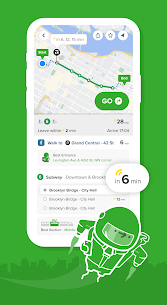
Find the best route
► Simple city navigation and trip planning combining bus 🚎 subway 🚇 train 🚄 ferry ⛴ cabs 🚕 ride share 🚖 car share 🚗 bike share 🚲 e-scooters 🛴 and walking 🚶♂️Discover routes you never knew existed 🕵️♀️!
Hit the GO button for step-by-step directions
► Turn-by-turn navigation for your transit, walking, cycling and scooter trips. Choose between 3 different map views, see the charge levels of e-scooters and e-bikes around you, and avoid no-parking zones. We take care of the logistical thinking with our smart route planner so you are free to enjoy the ride 🙌
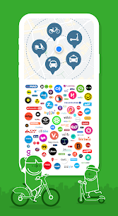
Experience one-stop-shop mobility
► Compare cab fares, hail a ride, hop on a shared bike or get on the nearest scooter. Our partners include: Uber, Lyft, JUMP, Lime, Bird, Spin, Skip, Scoot, Citi Bike, JerseryBike, Bluebikes, Indego, CaBi, Divvy, Metro Bike, Breeze, Bay Wheels, Healthy Ride, Relay, BCycle, SA Bike Share, GREENbike, Grid, RTC Bike, BIKETOWN, Biki 🚖 🚲 🛴
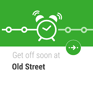
Beat the rush-hour crowd
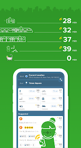
► Live wait times and ETA so you’ll never miss a bus, train or ferry again. Follow your public transportation as it’s approaching on a real-time map with our train & bus tracker. See the best train car to board, check the next train or bus stop, get alerted when it’s time to get off, and get in and out from the best exit at any subway / train station ⏰
Smarten up your daily transit navigation
► Get daily updates right on your lock screen for all public transportation: real-time bus arrivals, subway, ferry and train times, with disruption / delay / status alerts and alternative routes. Stay on top of any changes to your local bus schedule, train schedule or ferry timetable with the all-in-one transit tracker 🚨
Personalize your city navigation
► Save Home, Work and your go-to stops / stations for fast trip planning. Subscribe to your favorite subway, train, bus or ferry line for automatic disruption / delay / status alerts. Your local subway map, next bus time, subway time and train schedule at your fingertips ❤️
Get social
► Share your live trip: let friends follow your live trip to know when you’ll arrive. Share any location or address: one tap for others to get directions 🤳
Travel offline
► Access offline the official NYC subway map, Manhattan bus transit map, Brooklyn bus map, MTA map, Queens bus map, DC metro map, Muni metro map, and more 🗺
Works on Wear OS
► Hit GO in the app and automatically see all the information you need during your trip on your Wear OS watch.
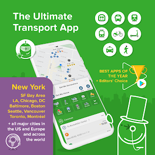
Cities
► New York City | Chicago | Los Angeles | San Francisco | Washington DC | Boston | Philadelphia | Seattle | Miami | Atlanta | Portland | Denver | Baltimore | San Diego | Minneapolis | Houston | Phoenix | Dallas | Las Vegas | Pittsburgh | Honolulu | Salt Lake City | San Antonio | St. Louis | Cleveland | Austin + Many more worldwide! See the full list and vote for the next one in the app or at https://citymapper.com/cities 🏙
Agencies
► We use open data from transit agencies, including: MTA | CTA | LA Metro | MBTA | WMATA | SEPTA | NJ Transit | Muni | BART | King Bus | MARTA | LIRR | RTD | TriMet | Metro-North Railroad | PATH | Houston METRO | San Diego MTS | Miami-Dade Transit | Metro Transit MN | METRA | RTC | TheBus | Port Authority | DART | AC Transit | Sound Transit | UTA | OCTA | VIA | PTD | St. Louis Metro Transit | RTA | Capital Metro | Broward County Transit Division | NY Waterway Ferries | LBT 📈
Keep in touch
► If you have any questions or feedback email us at: [email protected]
Like us on Facebook: http://facebook.com/thecitymapper
Follow us on Twitter: http://twitter.com/Citymapper
Visit our website: http://citymapper.com


This app is fantastic. 7 days in NYC with many subway rides, 3 train rides, and lots of walking, and we never got lost once! It saved our family a lot of stress and arguments. Way way better than google maps, particularly for mass transit. I highly recommend and will use it for every big city I visit in the future.
This app has been a life saver, I’m directionally challenged so I always use this app to travel. It provides alerts when trains have problems so I know which ones to avoid. The only downside is the walking directions can be a bit sketchy so a healthy dose of common sense is needed when following directions and sometimes it sends you on a longer route without presenting the short route. Overall it’s a lifesaver and has saved me a lot of time and energy.
Used to be great. I have used this app for years, and recommended it to everyone I know trying to get around New York. However, in the last month or so since the latest update, it crashes on me constantly while I’m on trips. Unless I’m looking at this phone screen the whole time I don’t know when I have stops coming up because it will just crash with no notification and I’ll go to check it but it’s off. On two occasions now I have missed stops going to places I was unfamiliar with.
I’ve used this app mostly while traveling on public transportation in NYC and I love it! The alerts for when your train stop is coming are genius and the expected arrival times and notifications on delays and the reasons for them are equallt helpful. The app is easy to understand and attractively designed.. Citymapper is much better than the MTA app for NYC. It’s also more responsive than Google maps. I highly recommend Citymapper for using public transportation or walking while traveling.
Almost perfect. I just wish that for the walking instructions I could fix the map with North up. It makes it much easier for me to figure out my way since the phone’s compass is often inaccurate. Right now I need to switch to Google Maps for walking directions just because of this.
I think this would be a really good app. I’ve used this app in Paris and London back in 2019 and had great results. I also used this app in Berlin and Lisbon back in 2021 and also had good results. I just don’t like how some of the cities such as Tokyo and Seoul are completely outdated or they only cover certain lines which is disappointing. I hope Citymapper brings their current cities up to date. I really like this app and its design, but I would really like to use this app in other cities.
This app is absolutely amazing in NYC. So helpful getting around. The app clearly tells you where to walk, what subway station you’re headed to, which subway to use, number of stops before getting off, and which direction to exit the subway. Absolutely amazing for someone exploring NYC for the first time.
I like Citymapper, especially the ability to get directions that including biking to transit, a feature which nobody else (including Transit & Google Maps) has. But I wish I could use transit & own bike (not just bikeshare). It’s main drawback is it’s complete lack of settings or customizability. It gives tons of different options for getting places, which I really like, but it needs options to filter & sort the results list, which can sometimes be overwhelmingly large. What if I just want the fastest option to show up at the top? Or perhaps I don’t have a scooter account and want to hide those options? Also, it has no settings, so there’s no way to customize the way the app works. I also wish it would show not only travel time but estimated arrival time.
A must have when traveling in cities!!!! This app was recommended by a youtuber and she was on target. Just put in where you want to go & either “now” or a set arrival or departure time & it gives tons of options with their corresponding times & costs. You can search ahead and save trips to use when you are offline. You can save locations which you use/need often. It has an alert to let you know when your stop is approaching. Sometimes following the walking while on the move is a bit confusing.
This is the greatest public transportation app I have ever seen and I don’t know how this works. Provides a smooth, step by step navigation with live data at every point and precise map view. The “Go” feature not only gives you a precise total arrival time including walking times but also encourages you with fancy statistics over your savings. Haven’t seen any visible ads so I heavily wonder how they monetize this great product ?!?
horrible app. got this app for my NY trip. horrible gps accuracy, seems to want to take you the longest route to get somewhere, times were wrong, buses don’t show up as an option to ride, if they are running, what seems to be, in more than half an hour. Always was wrong! thankfully I was with someone that knew how to read the paper maps.
No different than Google Maps. It says you can combine transit and biking but all I get are transit and WALKING directions. What gives? How are you failing at the one thing that differentiates you from Google Maps? It’s such a simple concept and yet nobody seems to be doing it correctly (or at all, in this case). I went from being excited when I found this app to becoming very frustrated and disgruntled. I was trying to get directions from a location in Concord, CA to a location in San Francisco. I have my own bike and don’t need to rely on a bike sharing service. This isn’t rocket science…
I usually dont write reviews, but living in NYC this is by far the most reliable and detail accurate mapping tool that I’ve used. I’m not from around here and city mapper makes it so easy to understand. One thing I like is that this app let’s you know the typical arriving time of a certain route. Things happen in real life and you can mentally adjust to the changes. City mappers let you be in control while allowing you to have the most accurate data. You guys are awesome!!
they only cover a limited amount of cities but they are great when they do cover them. it is much better than Google maps and I highly recommend for travel or if you even live in the city use this instead. note that the locations are very complete because it will match locations by name with Google maps so you won’t be missing anything!
Updated 10-2-2019 I live in the San Francisco Bay Area. I still looooove Citymapper. I use it almost every day. And many times a day. Works great, fast, good options, pretty easy to use, etc. One big improvement. Please make Citymapper for my Samsung Gear S3 Frontier Watch. I have tried several other transit apps for the watch and they suck. One app keeps saying can’t connect to server and it is slow. So, I have no working transit app on my watch at least that is fast and reliable.
Deleted my old comment to make a new one. Waste of space app that never has accurate bus times and reporting issues is a lost cause. Tried it out for over a year and it’s by far one of the worst transit apps I’ve downloaded. Save your time. This app has made me late to work and other places well over a handful of times. Accurate timing is a huge part of any transit tracking app and if they can’t get it right, what’s the point in downloading?
Great app! Love the fact you can share your location ETA with your contacts for more safety and accuracy. I travel to Staten island for work and it’s a headache not being able to use the go trip properly cause I cannot select ride types so I always get the Xpress buses which I don’t use. Also it does not let you modify or recognizes if you decide to change your route or use another stop more convenient than the one shown. For these reasons I’m changing back to Transit and only will use this when I need to share my ETA. Add inroute modifications and transit lines selection when doing a go trip.
I’ve been depending on public transportation for the past 2 years. I’ve been lucky to have discovered this app. I can literally plan to take a bus to a plane to a boat to a bicycle and then see how long of a walk to get to my destination. Citymapper will provide you the times & locations, all you have to do is provide the info. The only time I’ve had a problem is when the mode of transportation you’re using is off schedule. I thank this app for making my days less hectic and the ability to plan
Used this app on a recent trip to NYC. It was great. Got us to the closest subway or bus, told us when the next one was arriving and the correct stop to get off. Then gave directions to walk the rest of the way to our destination. Very helpful and easy to use even for someone not tech savvy. Highly recommend it.
Has been an amazing help when traveling. Having a good tourist travel pass is not much help if you actually don’t know transit system. We didnt have to waste time waiting for buses or trains because we knew exactly how long we had to get to the stop or station. I was able to pick the route with the least walking on bad weather days. This app makes it totally worth paying for a data plan when you travel abroad.
Not as useful as it could be. It’s fine for next departures, but when I get directions, I want the option to choose less walking, bus only, etc. The other day, it wanted me to walk 16 minutes at the end of the trip instead of showing the transfer time for another bus that stops three minutes from where I wanted to go. I now have to use two different apps to get the info I need since 511 discontinued providing the info on their web site .
Citymapper has enhanced my quality of life getting around on public transit in Chicago. Not only do I now get accurate real-time arrival data for trains & buses, I also know which L car to ride in, how long it’ll take me within an L station, & when my bus stop is coming up. Citymapper’s trip-time estimates are consistently more realistic than Google Maps’ underestimates, & Citymapper’s route options seem significantly better, too. The user interface is intuitive & beautiful. This app is great!
The best offline Transportation app ever, but of course you still need to have internet access to get the app started. Unlike Transit App, when you are in an area where there’s no service anywhere you don’t get lost and confused where to go like Transit App does. When there’s no Service anywhere around you, you can still use this app and not get lost. Thank you Citymapper people.
This app was indispensable when I visited Seoul, Korea. Googlemaps does not provide walking instructions in Korea, and the Naver app (English version) is clunky and lame. Citymapper was spot on for my ramblings sround Seoul. It was accurate for public transit options and for walking instructions. zThe interface is intuitive and thoughtfully designed. I wish it were available in more cities. Highly recommend.
The app is great at navigating me to the places I need to get too and be at on time. But the way the GPS acts is so inaccurate. It will give me routes and times that don’t even matchup. I can literally get to my destinations faster than the GPS for the app can tell me what time exactly I will get there which is way earlier than expected or way later than expected!
Most accurate I’ve tried (for all the big east coast US cities, at least), plus gives a lot of good options. Nice features, like mixed-mode and get-off notifications. Clean app. It has some customizations. I wouldn’t mind seeing a way to rank modes (walk, train, bus), but not critical
App completely fails to ever function as a mixed transportation mapper for someone in Baltimore, seemingly unable to factor in light rail, and no way to tell it to prefer bike. Ideal use-case being cycling a mile to light rail, light rail 8 miles north, then cycle about a mile to destination. An obvious use case, but none of the above ever maps in any use case.
I’ve used this app for over a year for catching the bus to work and planning my trips. The layout is easy to understand and trips are split into smaller segments you can view individually. It displays the MBTA schedules updated live, and the travel time estimates are usually (but not always) accurate. The hoverboard minigame is my favorite part
I usually do not write reviews but I felt I absolutely had to in regards to citymapper. I recently spent a few weeks in London with my wife and even with more complicated public transportation services, citymapper made it a breeze. Allowing you to not only use multiple forms of transportation at a time but also allowing you to share your travel time live with people and even request Ubers from directions you request. The only downside is that the app does not auto rotate on yourself.
It claims “all major US [and other] cities”, yet it doesn’t have a fair number of cities, including Detroit (or anything in Michigan). The only Ohio city appears to be Cleveland, no Cincinnati or Toledo. The nearest Canadian city is Toronto, nothing south of there, let alone the bus that runs across the border. On and on, I couldn’t find places near me. Very hit or miss. Back to Moovit with me. That app may be slow and bloated, but I can rely on it to work almost everywhere.
This is by far the best map navigation app I’ve ever used. I do however have a couple of request… the movable icon needs to be in the precise direction you’re facing, like an arrowhead icon. It’s a bit frustrating if I’m trying to go to 10th Avenue in NYC when the icon is pointing in the opposite direction. Also, it would be greatly beneficial if the app gives you a warning if you’re heading in the wrong direction. Just my two cents.
The voice function for this app doesn’t work unless you join Citymapper club or something, which is a monthly prescription, which means it would be almost too dangerous for bikers to use. I’m looking for an alternative to Google Maps as a navigation app and I guess this app won’t do until I can freely use the voice function.
This app is amazing. Saved my trip in NYC. It’s a MUST over any other map/direction app. It’s accurate, rarely loses connection in the subway, and gives you an alarm a stop in advance. The walking is the only thing that’s a little funky, but if you preview your trip you can acclimate yourself to the walking part before you get to where you need to go.
Amazing app for travel, commuting, or basic navigation. Has accurate and useful data in the places I’ve used it (Singapore and Seoul). I especially like that in Seoul it provides the best part of the subway to catch your transfer or exit. Walking navigation could be improved, but the other features make up for it!
Too hard to understand and follow. Not enough descriptions of what you should be looking for when traveling. Unable to use underground in subway. Icons don’t discribe what they mean. Not quick enough to update when there is a ‘problem’ due to unforeseen circumstances. Google maps was easier to use and follow.
I love this app. It gives you up to date info on cancelled trains, the mapping is pretty quick, and it’s very easy to use and get used to. The app converts your commute into how many trees you save, and calories you burn. It even gives you an alarm when it’s your stop so you can dose off 😉Good job guys.
I have to drop a star from my review earlier because of the following reason, the times are off, the app shows the next bus arriving in 0 minutes, and then the next bus is actually in 20 minutes, other people might have better luck than I’ve had with this app, but I’m uninstalling it due to the arrival times being so far off, I thought with all the high reviews it would be the app for me, but it’s not, if it can’t tell the correct times, then I have no use for it.
Perfect navigation tool for major metro areas. Gives accurate transit info, incl delays, along with options like ‘rain-safe,’ multiple transit system transfer, costs. The best feature, imo, is it tells you where you should get on the train to get off at the right exit and then they tell you which exit you should use.
Used in WA, DC . We were from a small town in the West. Helped us to navigate the the big city, find Restaurants and even play a video game. Suggested transportation options we had never seen before. We would pop up from a suggested metro stop and citymapper would get us to our final destinstion. Liked the fact that we could use it before we even got to DC to plan our itinerary.
This app has saved me so many times! Whenever my Metrolink train is cancelled or delayed, I check this app to find alternate routes to work. I love all the features, makes it simple to tell where you are on the route and reminds you when to get off the bus.